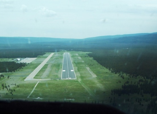
AVP -
Wilkes-Barre/scranton Intl,
Wilkes-Barre/scranton, PA
Any information displayed may not be accurate or current and should not be considered valid for navigation, flight planning, or for use in flight. Please consult official publications for current and correct information.
|
|
Location:
FAA Identifier:
|
AVP |
Latitude/Longitude:
|
41-20-18.5000N / 075-43-24.2000W 41.3383 / -75.7234
|
Elevation:
|
961 feet MSL (Surveyed) |
Magnetic Variation:
|
11W (1980)
|
Land Area Covered:
|
910 acres
|
From City:
|
5 nautical miles SW of Wilkes-Barre/scranton, PA
|
County/Parish:
|
Luzerne, PA
|
 |
|
|
Airport Operations:
Airport Use:
|
Public
|
Activiation Date:
|
1/1/1947 12:00:00 AM
|
Sectional Chart:
|
New York
|
Control Tower:
|
Yes
|
ARTCC:
|
New York Center (ZNY)
|
FSS:
|
Williamsport Flight Service Station ()
|
Attendance:
|
Continuous
|
Wind Indicator:
|
Yes - Lighted
|
Segmented Circle:
|
No
|
Lights:
|
|
Beacon:
|
White-Green (lighted land airport)
|
International Operations:
|
No
|
Landing Fee:
|
Yes
|
 |
|
|
Communications:
Unicom:
|
122.95 |
LCL/P
|
120.1 |
LCL/P
|
257.8 |
GND/P
|
121.9 |
EMERG
|
243.0 |
EMERG
|
121.5 |
ATIS
|
111.6 |
APCH/P DEP/P TRSA RDR
|
126.3 101-279 |
APCH/P DEP/P TRSA
|
256.7 |
APCH/P DEP/P TRSA
|
120.95 280-100 |
 |
|
|
Services:
Fuel available:
|
100LL Jet-A |
Airframe Repair:
|
Major |
Power Plant Repair:
|
Minor |
Bottled oxygen:
|
Low |
Bulk oxygen:
|
Low |
 |
|
|
Runway Information:
Runway: |
04/22 |
Dimensions:
|
7501 x 150 ft. |
Surface:
|
Asphalt - in good condition |
Surface Treatment:
|
Saw-cut or plastic groove |
Weight Bearing Capacity:
|
Single wheel: |
133 K lbs. |
Double wheel: |
173 K lbs. |
Double tandem: |
300 K lbs. |
|
Runway Edge Lights:
|
High intensity |
 |
|
 |
Runway 04 |
 |
Runway 22 |
Latitude: |
41-19-43.3132N |
Latitude: |
41-20-45.6731N |
Longitude: |
075-43-53.5083W |
Longitude: |
075-43-00.3912W |
Elevation: |
962 ft. |
Elevation: |
911 ft. |
Gradient: |
0.7% |
Gradient: |
0.7% |
Traffic Pattern: |
Left |
Traffic Pattern: |
Right |
Displaced Threshold: |
No |
Displaced Threshold: |
No |
Declared distances: |
7501 Feet - Actual Stop Distance Available. 7501 Feet - Take Off Distance Available. 7501 Feet - Landing Distance Available. 7501 Feet - Take Off Run Available.
|
Declared distances: |
7501 Feet - Actual Stop Distance Available. 7501 Feet - Take Off Distance Available. 7501 Feet - Landing Distance Available. 7501 Feet - Take Off Run Available.
|
Markings: |
PIR - Precision instrument, Good condition |
Markings: |
PIR - Precision instrument, Good condition |
Visual Glide Angle: |
3° |
Visual Glide Angle: |
3° |
RVR Equipment: |
touchdown, rollout |
RVR Equipment: |
touchdown, rollout |
Approach Lights: |
MALSR |
Approach Lights: |
|
Runway End Identifier Lights: |
|
Runway End Identifier Lights: |
Yes |
 |
|
 |
|
Runway: |
10/28 |
Dimensions:
|
4300 x 150 ft. |
Surface:
|
Asphalt - in good condition |
Surface Treatment:
|
Saw-cut or plastic groove |
Weight Bearing Capacity:
|
Single wheel: |
58 K lbs. |
Double wheel: |
80 K lbs. |
Double tandem: |
125 K lbs. |
|
Runway Edge Lights:
|
Medium intensity |
 |
|
 |
Runway 10 |
 |
Runway 28 |
Latitude: |
41-20-26.1633N |
Latitude: |
41-20-24.8861N |
Longitude: |
075-43-47.6600W |
Longitude: |
075-42-51.3141W |
Elevation: |
922 ft. |
Elevation: |
934 ft. |
Gradient: |
0.3% |
Gradient: |
0.3% |
Traffic Pattern: |
Right |
Traffic Pattern: |
Right |
Displaced Threshold: |
No |
Displaced Threshold: |
No |
Declared distances: |
4300 Feet - Actual Stop Distance Available. 4300 Feet - Take Off Distance Available. 4300 Feet - Landing Distance Available. 4300 Feet - Take Off Run Available.
|
Declared distances: |
4300 Feet - Actual Stop Distance Available. 4300 Feet - Take Off Distance Available. 4300 Feet - Landing Distance Available. 4300 Feet - Take Off Run Available.
|
Markings: |
NPI - Non-precision instrument, Good condition |
Markings: |
NPI - Non-precision instrument, Good condition |
Visual Glide Angle: |
3° |
Visual Glide Angle: |
° |
Runway End Identifier Lights: |
Yes |
Runway End Identifier Lights: |
Yes |
 |
|
 |
|
|
Airport Ownership and Management:
Ownership:
|
Publicly Owned |
Owner:
|
Luzerne And Lackawanna Co 100 Terminal Drive Avoca, PA 18641 (570) 602-2040
|
Manager:
|
Carl R. Beardsley, Jr. 100 Terminal Drive Avoca, PA 18641 570-602-2000
|
 |
|
|
Remarks:
- THIS AIRPORT HAS BEEN SURVEYED BY THE NATIONAL GEODETIC SURVEY.
- DEER & BIRDS ON & INVOF ARPT.
- RY 28 UNLGTD HIGH TERRAIN TREES: 1155 FT MSL .91 MI EAST AER 28; 1463 FT MSL 1.49 MI EAST-SOUTHEAST AER 28; 1667 FT MSL 2.25 MI EAST AER 28; 1920 FT MSL 2.84 MI EAST AER 28.
- UNLGTD TOWER 1130 FT MSL (20 FT AGL) 1.3 MI EAST AER 28; UNLGTD TOWER 1463 FT MSL (20 FT AGL) 1.7 MI EAST AER 28; UNLGTD TOWER 1652 FT MSL (20 FT AGL) 2.4 MI EAST AER 28.
- FOR FBO SERVICE 0000-0500 LOCAL M-F AND 2100-0000 LOCAL SAT-SUN CALL (570) 457-4485.
- COLD TEMPERATURE RESTRICTED AIRPORT. ALTITUDE CORRECTION REQUIRED AT OR BELOW -21C.
- INDEX "C" ARFF EQUIPMENT AVAILABLE UPON REQUEST CALL 570-602-2040.
- PRECIPITOUS DROP-OFF EACH RY END.
- VGSI AND ILS GLIDEPATH NOT COINCIDENT.
- EXISTED PRIOR TO REQMT FOR AIRSPACE DETER.
- ENGINEERED MATERIAL ARRESTING SYSTEM (EMAS) 324 FT IN LENGTH BY 170 FT IN WIDTH LCTD 50 FT OFF DER 04.
- ENGINEERED MATERIAL ARRESTING SYSTEM (EMAS) 162 FT IN LENGTH BY 170 FT IN WIDTH LCTD 35 FT OFF DER 22.
|
|
FunPlacesToFly.com and OpenAirNet Inc. shall not be held liable
for any financial loss, damages or injury due the use of, or reference
to the information displayed above. Always call ahead to
confirm any information listed and the existence of the destination.
Any information displayed may not be accurate or current and should
not be considered valid for navigation, flight planning, or for use in flight.
Please consult official publications for current and correct information.
Please read our Disclaimer.
|
|