
Fun Places to Fly, Aviation Jobs and More!


Lookout Mountain Incline Railway
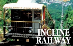
The Lookout Mountain Incline Railway is an inclined plane railway located along the side of Lookout Mountain in Chattanooga, Tennessee. Passengers are transported from St. Elmo's Station at the base, to Point Park at the mountain summit, which overlooks the city and the Tennessee River. The railway is approximately one mile 1.6 km in length single track except for a short two-track stretch at the midway point, allowing operation of two cars at one time, and has a maximum grade of 72.7. It is billed as one of the world's steepest passenger railways. The inclined railway is just part of the area attractions.
All destinations and events listed on this website were provided by visitors to our website. If you decide
to fly or drive to any destination listed, you do so at your own risk. Please see our disclaimer.
We got courtesy car and also visited Rock City. Rock City features a long, convoluted rock trail lined with gardens. These gardens contain hundreds of labeled local trees and plants. The trail also leads through a variety of bizarre rock formations, including the 1000-ton Balanced Rock and the Fat Man's Squeeze. Two other sections, the Fairyland Caverns and father Goose Village, are rock caves decorated with blacklight-responsive sculptures. This is a daddy daughter dream day. I plan on going back soon to see Ruby falls. Ruby Falls is a 145-foot high underground waterfall located within Lookout Mountain. - Submitted by Larry Carvagno |

Contact Information:
Phone: 423 821-9056
Phone: 423 821-9056
Airport Information:
|
Lovell Field (CHA) Latitude: 35-02-06.7000N |
|
|
Location:
|
3917 Saint Elmo Avenue Chattanooga, TN |
Comments and Reviews From FunPlacesToFly.com Visitors:
Write a review, suggest updates or make comments!
Write a review, suggest updates or make comments!
- No reviews so far
Nearby Public Airports: (50 mile radius)
|
Photos:
All photos shown below are provided/uploaded by visitors to our website, which have agreed to our Photo Submission Rules.
Got a photo?, share it with us
Lookout Mountain Incline Railway - Uploaded by Mike Watson
All photos shown below are provided/uploaded by visitors to our website, which have agreed to our Photo Submission Rules.
Got a photo?, share it with us
Lookout Mountain Incline Railway - Uploaded by Mike Watson
FunPlacesToFly.com is an Amazon Associate. As an Amazon Associate we earn from qualifying purchases.


Advertise with us!
 |
 |
 |
 |
 |
 |
 |
 |
 |
 |
 |
 |