
Fun Places to Fly, Aviation Jobs and More!


Big Bear Airport

High altitude airport ski resort. Hiking and several good restaurants in the area. Big Bear City Airport is located in Southern California, approximately 40 miles outside of the Los Angeles metropolitan area, on the southern boundary of the San Bernardino Mountain Range. The Airport provides a safe operating environment for general aviation aircraft, ranging from gliders to small corporate jets. - Submitted by newslinknet
All destinations and events listed on this website were provided by visitors to our website. If you decide
to fly or drive to any destination listed, you do so at your own risk. Please see our disclaimer.
|
|
Amenities:  100LL
JET-A
Maintenance
Tiedowns 100LL
JET-A
Maintenance
Tiedowns
|
Airport Information:
|
Big Bear City (L35) Latitude: 34-15-49.6000N |
|
|
Location:
|
P.O. Box 755 Big Bear, CA |
Comments and Reviews From FunPlacesToFly.com Visitors:
Write a review, suggest updates or make comments!
1/10/2026 - Big bear will privide a free shuttle to take you to town and they'll also send it to bring you back. Our favorite lunch spot is Murray's Saloon and Eatery. - Submitted by Michael
12/30/2011 - Great airport to practice your high altitude t/o landing skills on well maintained, flat 5850' runway at 6750' altitude. Getting up there will visually freak you out if you're not used to mountain flying you see nothing but mountains within gliding distance, but good for building pilot confidence. Barnstormer is a great cafe right there on the airport. Hang around long enough you you can see lots of interesting stuff land at a/p including Forest Service a/c with smoke jumpers loading for practice jumps in the area and military pilots flying airbase flight club aircraft in for a quick breakfast/lunch at the Barnstormer. Two blocks south is Hwy 18 easy to make it into Big Bear City on transit system 3 miles to west. Best flying waether is late winter/early spring or fall. If you go during the summer, make sure you know what you're doing since it will be possible to land, but you may not be able to take-off due to desnity altitude issues. - Submitted by Ken
8/25/2011 - Big Bear City Airport is located in Big Bear City, California. Situated in the San Bernardino mountain range, 6,752 feet above sea level, the Airport serves several of the surrounding small communities, as well as Southern California's only four season resort, Big Bear, with general aviation air service. Big Bear City Airport is open to the general public and to visiting aircraft 24 hours a day. Although the Airport does not have any commercial passenger activity, it does provide services such as aircraft maintenance, sightseeing flights, aircraft charter, aircraft sales and rentals, a flight school, emergency services and aerial photography. http://bigbearcityairport.com - Submitted by Cindy Venuto
9/7/2010 - Actually the Barnstorm restaurant is great for breakfast and for lunch. Try the Crab Cakes Benedict and enjoy the view of other pilots flying in and out. Highly recommended. Pretty well cheapest 100LL in the area too. - Submitted by Maris
6/8/2002 - 6/6/02 - great vacation place. We rented a house for a week, very reasonable rentals available. Plenty of things to do. The Village shopping, water slide, mountain slide, boat rentals. The airport was friendly and easy to fly into. Car rentals on field, or Enterprise. Big Bear Chamber helpful. Shauna & Donald, Samoa Airport B&B Inkeepers.
Nearby Public Airports: (50 mile radius)
|
Photos:
All photos shown below are provided/uploaded by visitors to our website, which have agreed to our Photo Submission Rules.
Got a photo?, share it with us
Big Bear Airport - Uploaded by sstolarik
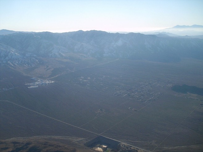
The Big Bear Mountains from the north with Lucerne Valley over 4000ft below. The typical approach is through the pass to the left of this view. - Uploaded by sstolarik
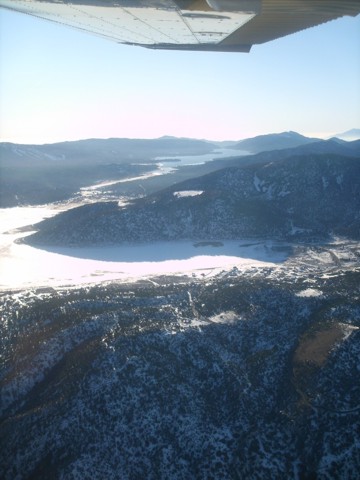
Flying through the pass at 10,000ft to enter the Big Bear traffic pattern from the East. Few airports have such a grand entrance. - Uploaded by
All photos shown below are provided/uploaded by visitors to our website, which have agreed to our Photo Submission Rules.
Got a photo?, share it with us
Big Bear Airport - Uploaded by sstolarik
The Big Bear Mountains from the north with Lucerne Valley over 4000ft below. The typical approach is through the pass to the left of this view. - Uploaded by sstolarik
Flying through the pass at 10,000ft to enter the Big Bear traffic pattern from the East. Few airports have such a grand entrance. - Uploaded by
FunPlacesToFly.com is an Amazon Associate. As an Amazon Associate we earn from qualifying purchases.


Advertise with us!
 |
 |
 |
 |
 |
 |
 |
 |
 |
 |
 |
 |