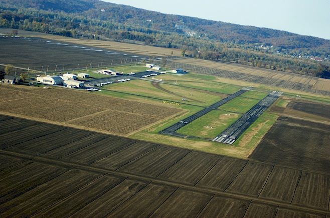
St Charles County Smartt Airport
|
Home of the Missouri Wing, Commemorative Air Force. The Missouri Wing of the Commemorative Air Force. Dedicated volunteers maintaining and educating the public about WWII aviation. We currently have a B-25 Mitchell, TBM Avenger, and L-3 Aeronca. Visit us in St. Charles, MO! - Submitted by Bert Hampton
All destinations and events listed on this website were provided by visitors to our website. If you decide
to fly or drive to any destination listed, you do so at your own risk. Please see our disclaimer.
|
|
Amenities:  100LL 100LL
 Aircraft Rental Aircraft Rental
 Flight Training Flight Training
 Hangars Hangars
 Maintenance Maintenance
 Tiedowns Tiedowns
|
Contact Information:
Phone: 636-250-3200
Phone: 636-250-3200
Airport Information:
|
St Charles County Smartt (SET) Latitude: 38-55-46.9000N |
|
|
Location:
|
6390 Grafton Ferry Rd. St. Charles, MO |
Comments and Reviews From FunPlacesToFly.com Visitors:
Write a review, suggest updates or make comments!
9/19/2012 - No RESTURANT, but in October, St.Charles Flying Service hosts the annual Pumpkin Drop! It's an open house with a pumpkin bombing contest, fuel discounts, BBQ, music and lots of airplanes. The CAF usually flies the B-25 Sho-Me and s a bomb load of pumpkins. Lots of fun. - Submitted by David
9/13/2011 - The restaurant is no longer open at Smarrt Field - Submitted by Gale
Nearby Public Airports: (50 mile radius)
|
Photos:
All photos shown below are provided/uploaded by visitors to our website, which have agreed to our Photo Submission Rules.
Got a photo?, share it with us

On approach to 36 for a low approach and pumpkin bombing run at the annual Pumpkin Drop. - Uploaded by David Kincade - Copyright Holder: David Kincade Photography
All photos shown below are provided/uploaded by visitors to our website, which have agreed to our Photo Submission Rules.
Got a photo?, share it with us

On approach to 36 for a low approach and pumpkin bombing run at the annual Pumpkin Drop. - Uploaded by David Kincade - Copyright Holder: David Kincade Photography
FunPlacesToFly.com is an Amazon Associate. As an Amazon Associate we earn from qualifying purchases.
Advertise with us!
 |
 |
 |
 |
 |
 |
 |
 |
 |
 |
 |
 |
 |


