
Fun Places to Fly, Aviation Jobs and More!


Chino Airport
Chino Airport (CNO), formerly known as Cal Aero Field, is a general aviation reliever airport, which serves private, business, and corporate tenants from Southern California. Chino Airport is situated on 1,100+ acres and features three runways: 4,858' instrument runway, 7,000' non-precision runway, and a 4,419' non-precision cross-wind runway. The Airport is conveniently located 3 miles south east of the City of Chino and is situated minutes from Los Angeles, Orange, and Riverside Counties. Chino Airport is rich with history; rooted back to the early 1940's when the airport was home to the Cal Aero Cadets. The Airport has transformed from a training facility for the war effort into a major economic engine for the Southern California region. Chino Airport has over 600 based aircraft, 100 businesses, 2 aircraft museums, the ever popular Flo's Cafe, and 345 days of VFR weather. With room to grow, Chino Airport is your flight to opportunity.
All destinations and events listed on this website were provided by visitors to our website. If you decide
to fly or drive to any destination listed, you do so at your own risk. Please see our disclaimer.
- Submitted by David |
|
Amenities:  100LL
Hangars
JET-A
Maintenance
Oxygen
Tiedowns 100LL
Hangars
JET-A
Maintenance
Oxygen
Tiedowns
|
Airport Information:
|
Chino (CNO) Latitude: 33-58-29.2055N |
|
|
Location:
|
7000 Merrill Ave Chino, CA |
Comments and Reviews From FunPlacesToFly.com Visitors:
Write a review, suggest updates or make comments!
2/26/2022 - In the early to mid 60's in hangar 4 there was a mobile home mfg, Karson Industries which i worked for when I was in my early 20's. I am now 80. I never see any history on this, nothing on Google either. In hangar 1 California Mobile homes was another business. No Flo's than but numerous dairy farms and orange groves. Any comments or history available? During that ere they filmed the tv series 12'oclock high. Those P51 Mustangs were fun to watch. - Submitted by Don Plath
Nearby Public Airports: (50 mile radius)
|
Photos:
All photos shown below are provided/uploaded by visitors to our website, which have agreed to our Photo Submission Rules.
Got a photo?, share it with us
Chino Airport - Uploaded by Mike
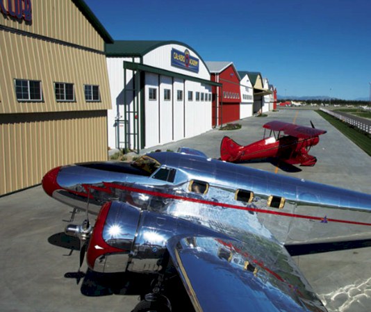
Chino Airport - Uploaded by Mike
All photos shown below are provided/uploaded by visitors to our website, which have agreed to our Photo Submission Rules.
Got a photo?, share it with us
Chino Airport - Uploaded by Mike
Chino Airport - Uploaded by Mike
FunPlacesToFly.com is an Amazon Associate. As an Amazon Associate we earn from qualifying purchases.


Advertise with us!
 |
 |
 |
 |
 |
 |
 |
 |
 |
 |
 |
 |