
Fun Places to Fly, Aviation Jobs and More!


Paoli Airport

A reall fun place to visit. Old town square around the original courthouse. Lots of antique stores, places to eat and shop. Amish arts and crafts throughout the county to visit. Paoli Peaks Ski Resort two miles out of town. French Lick 9 miles away and not far from great fishing in Patoka Lake. Spring Mill State Park is only about 12 miles away and Marengo Caves are a short distance away. Come see the friendliest town in southern Indiana. - Submitted by balerop
All destinations and events listed on this website were provided by visitors to our website. If you decide
to fly or drive to any destination listed, you do so at your own risk. Please see our disclaimer.
|
|
Amenities:  100LL
Tiedowns 100LL
Tiedowns
|
Airport Information:
|
Paoli Muni (I42) Latitude: 38-35-07.6550N |
|
|
Location:
|
186 W. Applegate Street Paoli, IN |
Comments and Reviews From FunPlacesToFly.com Visitors:
Write a review, suggest updates or make comments!
9/14/2015 - Aviation Day Fly in Sept. 19 th 2015.
Free breakfast or lunch for pilots flying in.
8am to 4pm free Parking and free admission. - Submitted by John Deringer
12/30/2013 - Very friendly. Be sure to ask about the German Restaurant Diner in town! - Submitted by Drew Chaplin
7/15/2012 - You also can camp on field with your plane or head into the woods to camp. It is the freindlist place I know . - Submitted by buster
12/19/2009 - Paoli Peaks are OPEN! Fly IN to our airport and use the courtesy van to drive over to the Peaks! Paoli Peaks is www.paolipeaks.com
- Submitted by John Deringer
12/17/2009 - Paoli Airport's New Website: www.paoliairport.com Check it out! - Submitted by John Deringer
11/10/2009 - Airport Email is paoliairport@yahoo.com. AVGAS 100LL availiable Cash or Check only. Tie downs or overnight hanger available. Courtesy van available close to Casino, Walmart, Skiing, Lodging, Restaurants,Parks, Lakes. - Submitted by John D.
11/10/2009 - Avgas100LL availiable hrs 8am to 5pm or call for after hours. Tie downs or overnight hanger availiable. Courtesy van available. 2800 ft paved runway with papi lights. Lounge area with kitchen and showers. - Submitted by John Deringer airport manager
11/10/2009 - Area Attractions: French Lick Casino, golfing, indoor water park just 10 miles away. - Submitted by John Deringer Airport Manager
Nearby Public Airports: (50 mile radius)
|
Photos:
All photos shown below are provided/uploaded by visitors to our website, which have agreed to our Photo Submission Rules.
Got a photo?, share it with us
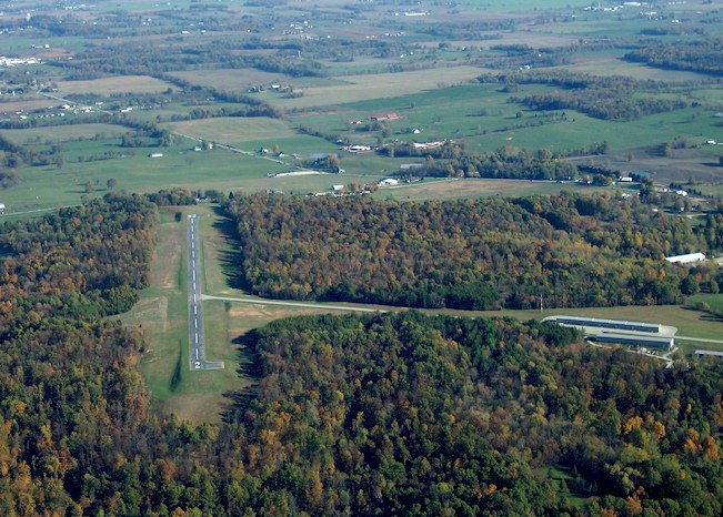
RNWY 2 / 20 - Uploaded by John Deringer
All photos shown below are provided/uploaded by visitors to our website, which have agreed to our Photo Submission Rules.
Got a photo?, share it with us
RNWY 2 / 20 - Uploaded by John Deringer
FunPlacesToFly.com is an Amazon Associate. As an Amazon Associate we earn from qualifying purchases.


Advertise with us!
 |
 |
 |
 |
 |
 |
 |
 |
 |
 |
 |
 |