
Fun Places to Fly, Aviation Jobs and More!


Lee Bottom Flying Field
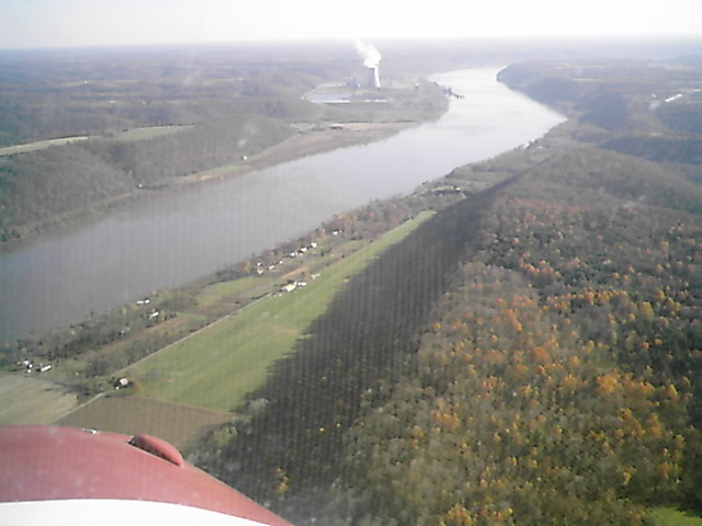
Bring your picnic lunch and visit this scenic little place on the Ohio River. The 'Wood, Fabric and Tailwheel' Fly-In hosted the last Saturday in September boasts over 150+ vintage aircraft. North/South grass runway with all traffic over the river. - Submitted by planecrazy13
All destinations and events listed on this website were provided by visitors to our website. If you decide
to fly or drive to any destination listed, you do so at your own risk. Please see our disclaimer.
|

Contact Information:
Email: ggordon@iflytimepieces.com
Email: ggordon@iflytimepieces.com
Airport Information:
|
Lee Bottom (64I) Latitude: 38-37-53.1900N |
|
|
Location:
|
Hanover, IN |
Comments and Reviews From FunPlacesToFly.com Visitors:
Write a review, suggest updates or make comments!
11/5/2006 - Embraced between the Ohio River and an 800' ridge line is a wonderful flyin destination called Lee Bottom Flying Field 64I, located just outside of Madison, IN. A smooth as glass, wide grass strip, perfect for classic planes. Rich and Ginger Davidson run the public use airport and have some Richard Bach size dreams of creating an historic aviation sanctuary. I just completed three days of tail wheel training with Ginger, CFI in her Champ and stayed on field in the guest cabin. River barges cruise buy regularly. In-fact the downwind is directly over the Ohio River. A nearby coal power station provides easy wind direction indication.
Nearby Public Airports: (50 mile radius)
|
Photos:
All photos shown below are provided/uploaded by visitors to our website, which have agreed to our Photo Submission Rules.
Got a photo?, share it with us
Lee Bottom Aerial - Uploaded by Andy
All photos shown below are provided/uploaded by visitors to our website, which have agreed to our Photo Submission Rules.
Got a photo?, share it with us
Lee Bottom Aerial - Uploaded by Andy
FunPlacesToFly.com is an Amazon Associate. As an Amazon Associate we earn from qualifying purchases.


Advertise with us!
 |
 |
 |
 |
 |
 |
 |
 |
 |
 |
 |